Wellhead Protection Areas (WHPAs)
Municipal wells are relied on for safe, clean drinking water by three percent of the population of the source protection region. The municipal supplies are used in parts of the communities of Campbellville, Carlisle, Freelton, Greensville and Milton.
A wellhead protection area (WHPA) is an area on the ground surface that reflects a zone in an aquifer where groundwater is flowing to a pumping well. Activities undertaken in this area may release pollutants that could seep into the soil and contaminate the groundwater used by both domestic and municipals wells. Accordingly, this area warrants greater protection.
The level of risk to the groundwater quality at the well is in relation to the time it takes for a contaminant to travel to the well and the time available for water operators to assess and mitigate the situation. For example, if a chemical spill occurs a considerable distance away from a well, an assessment will be required. The assessment considers whether the spilled chemical will reach the well and how long it will take; whether the chemical is a health risk or an aesthetic parameter; whether the concentrations of the chemical at the well will exceed the provincial standard; and whether the existing treatment process is adequate to remove or reduce the concentrations of that chemical. If sufficient time is available, a mitigation system may be installed to limit the movement of the chemical to the well or the water treatment process may be modified to adequately lower the concentrations. If time is available, the risk to the water supply is lower.
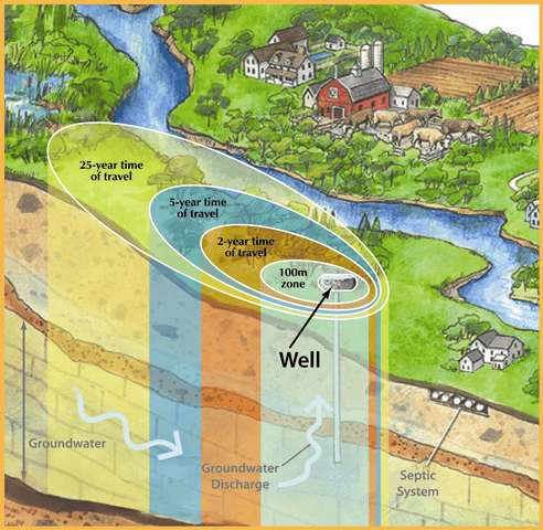
Accordingly, for the purposes of source protection planning, the wellhead protection area has been divided into the following parts:
- WHPA-A – an area of 100 metre radius around the wellhead
- WHPA-B – the zone through which it takes groundwater to travel between two years and the 100 metre distance
- WHPA-C – the zone through which it takes groundwater to travel between five and two years
- WHPA-D – the zone through which it takes groundwater to travel between 25 and five years
- WHPA-E – the area on ground surface through which surface water flows in two hours to a point close to the well. This wellhead protection area is only delineated when studies have shown that surface water can relatively easily seep through the soil and impact the quality of the water at the well. This situation is known as groundwater under the direct influence of surface water, or a GUDI well
Modelling was used to delineate the wellhead protection areas and to estimate the time of travel for groundwater to reach each well. For a WHPA-E, essentially an intake protection zone was defined with the intake being the closest point on the watercourse to the well. The modelling work is described in more detail in the technical reports included in the Documents and Maps section of this website.
Vulnerability of a Well’s Source Water
As mentioned above, a wellhead protection area identifies an area on the ground surface that reflects a zone in the aquifer where groundwater is flowing to the pumping well. This area is not necessarily equal to the actual area contributing water to the well in a given amount of time. The contributing area is the location on the ground surface where water seeping through the soil will actually reach the well. It is this area that requires the highest degree of protection because it is this area that is most sensitive to surface contamination.
The vulnerability of the source water is assessed by calculating the time for water to travel through the unsaturated zone above the water table and adding that time to the modelled time it takes for groundwater to flow from the water table to the well. It is determined that some of the water within the wellhead protection area does not actually reach the well within 25 years or by-passes the well altogether. Waters that by-pass the well are expected to continue flowing downgradient or discharge into a local surface water feature, such as a stream or wetland.
These surface to well advection times are categorized as low for over 25 years, medium for 5 to 25 years, and high for 0 to 5 years of travel. The mapped groundwater vulnerability areas are overlain on the wellhead protection areas A through D in order to assign vulnerability scoring between 2 (lowest vulnerability) and 10 (highest vulnerability).
The location within the wellhead protection areas and its vulnerability score are used to assign significance to identified or potential activities that have been deemed threats to the drinking water sources. This topic is discussed in more detail on the Drinking Water Threats webpage.
Wellhead Protection Area Mapping
Simple maps of the wellhead protection areas are available for review and download by clicking here:
- Halton Region Source Protection Area – Kelso, Campbellville, Walkers Line, Freelton, Carlisle
- Hamilton Region Source Protection Area – Greensville
For more detailed mapping of the wellhead protection areas please review the appropriate assessment report.
Maps are also available that illustrate the vulnerability scores assigned within the wellhead protection areas. There are individual maps for each well field available for review and download by clicking on the appropriate well field name below.
Kelso, Campbellville, Walkers Line, Freelton FDF01, Freelton FDF03, Carlisle, Greensville


